1-Map grazing land
Map farm grazing land into pasture zones based on land class and capability
Guidelines to mapping farm grazing land into pasture zones
Assess the soil characteristics and topography of land allocated to the beef enterprise and define pasture zones according to the potential of the grazing land to support high-quality pasture composition and growth and environmental stability.
This assessment involves developing a map of grazing lands to define land capability based on primary land use, pasture productivity, soil, and spatial and environmental constraints (see Tool 2.1 for guidelines). The classification allows for variation in management practices to achieve best possible pasture growth and quality while ensuring economic and environmental sustainability.
Higher land class numbers indicate there are greater limitations to land use. Higher levels of inputs and expertise will be required to manage the land. Within each landclass there are a range of limitations. These limitations can be caused by climate, soil type, slope of the land, aspect, nutrient levels, acidity, salinity, drainage and presence of stones. To make full use of the capability of the landclass, these limitations need to be managed.
Create accurate maps to assist with precision planning
Mapping enables better planning of the pasture resource base to maximise water use efficiency and adjustment of stocking rates to minimise under and oversupply of pasture throughout normal seasonal variations. It also shows where environmental damage may occur from unsuitable fertiliser application and cultivation practices. Both on-site and off-site impacts of management actions need to be considered when mapping the land classes.
Manage each pasture zone carefully to achieve full productivity potential
To maximise the productivity of your grazing land, you need to manage each pasture zone differently to ensure the needs of each zone are met, such as aligning fences to soil types, installing water points to allow better grazing management or maintaining critical ground cover targets to minimise erosion (see Tool 2.2 for groundcover guidelines). Providing new infrastructure may involve significant capital expenditure, so you need to examine the marginal returns on such an investment and look carefully at cash flow budgeting to determine your priorities.
Map pasture zones
The following visual characteristics can be used to assess grazing land and identify different pasture zones (see Tool 2.1):
- Soil texture: define areas of different soil textures; where there is a change of more than one class for either A or B horizons, create a new pasture zone (see Tool 2.3 for simplified soil texture classes).
- Slope: define areas where the slope is greater than 10º. Slope determines the volume and speed of water run-off.
- Aspect: identify north-facing slopes as +/- 30º from due north, and south-facing slopes as +/- 30º degrees from south.
- Streams and drainage lines (riparian areas): define the areas 5-10m from the top of the stream bank to disperse flows and prevent soil and nutrients from entering streams and rivers.
- Salinity (EC): identify areas where soil salinity is limiting pasture growth and productivity by looking for the visual indicators described in Tool 2.4.
- Primary land use: separate land used primarily for cropping or specialty fodder crops.
Assess existing farm plans and maps against this list and overlay the common mustering routes. Where limitations are identified or no farm map has been prepared, use the guidelines provided in Tool 2.1 to develop a plan. Tools 2.2, Tool 2.3 and Tool 2.4 provide further assistance in mapping farm grazing land into pasture zones based on landclass and capability. Your local state department may also run courses in whole farm planning, as do many TAFE colleges.
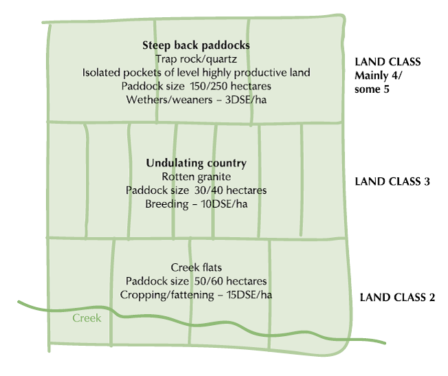
Figure 1 shows how one producer mapped the property, ‘Greener Pastures’, into distinct pasture zone. You can simply chart information such as topography, location, soil type, paddock size, class of stock and average stocking rates for your own farm.
What to measure and when
As part of the annual planning cycle, review the grazing lands map to determine whether it still accurately shows land capability and class. The map may need to be updated to incorporate any new knowledge or changes in practice or measures (eg appearance of new saline discharge areas). The growth of tree lines over time may change animal behaviour.